The Beginning
Early experiments that set the stage for unmanned flight and remote control concepts.

| Comparison | UAV | Drone |
|---|---|---|
| Definition | A specific type of aircraft that flies without a human pilot onboard. | A general term used for any remotely operated or autonomous robotic vehicle. |
| Scope | Refers ONLY to airborne vehicles. | Covers air, land, sea, underwater robots. |
| Usage Context | Used in military, aerospace, and engineering. | Commonly used in commercial, hobby, and public contexts. |
| Technicality | Formal, technical aviation term. | Simple, common public term. |
| Control Type | Autonomous, semi-autonomous, or remotely piloted. | Mainly remote-controlled; may also be autonomous. |
| Regulatory Use | Authorities use “UAV / UAS / RPAS”. | “Drone” rarely used in official regulations. |
Early experiments that set the stage for unmanned flight and remote control concepts.
Development of reliable radio and control systems became foundational for UAVs.
Integration of radio guidance and early autopilot technologies enabled more complex missions.
Often cited as one of the first modern unmanned aircraft experiments — a key historical milestone.
Target drones were used for weapons testing and gunnery practice.
Early assault and expendable drones were fielded in limited roles during WWII.
The V-1 was a pioneering cruise missile / pilotless aircraft used by Germany.
Mistletoe (or similar programs) represented guided weapon experiments—part of wartime innovation.
Reconnaissance drones began to appear for surveillance and intelligence collection.
Decoys were used to spoof radar and protect manned assets — an important tactical application.
Long-range unmanned systems expanded strategic surveillance capabilities.
Vertical-lift unmanned systems emerged, enabling different mission profiles.
Research pushed toward autonomy: path planning, sensors, and onboard decision-making.
Twin-boom pusher designs became popular for some surveillance and endurance platforms.
Operational use of UAVs grew markedly during the 1991 Gulf War — a turning point for adoption.
Operational trust and doctrine evolved to accept unmanned platforms in combat and routine roles.
Ongoing discussion on roles, ethics, and practical limits of unmanned vs. manned aviation.
Tip: drag horizontally or use the arrows / keyboard ← → to navigate.
•Digital sky platform being developed as a user-friendly online single-window system. There will be minimal human interface and most permissions will be self-generated
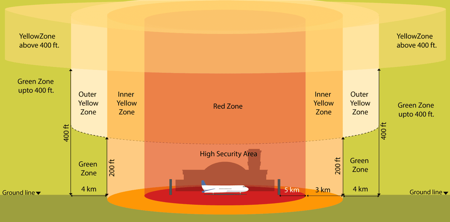
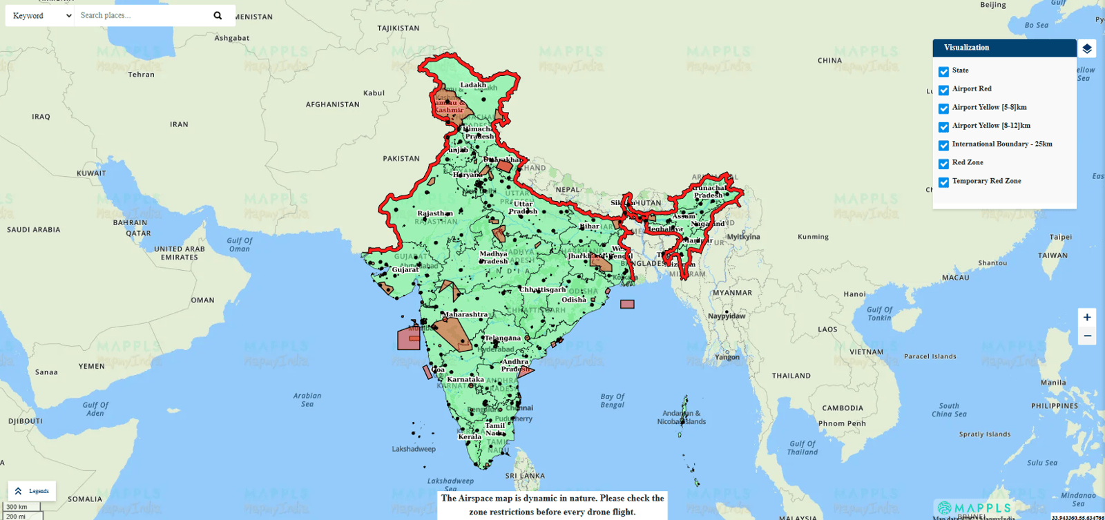
•Interactive drone airspace map with red and yellow zones shall be displayed.
• No permission required for operating drones in green zones.
• Yellow zone, where ATC permission is required, has been reduced from 45 km to 12 km from the airport perimeter.
• No remote pilot licence required for micro drones (for non-commercial use) and nano drones.
• No requirement of Type Certificate, unique identification number and remote pilot licence by R and D entities operating drones in own or rented premises, located in a green zone.
• Import of drones to be regulated by DGFT.
• Requirement of import clearance from DGCA abolished.
• No security clearance required before issuance of any registration or license.
• Coverage of drones under drone rules, 2021 increased from 300 kg to 500 kg. This will cover drone taxis also.
• DGCA shall prescribe drone training requirements, oversee drone schools and provide pilot licences online.
• No restriction on foreign ownership in Indian drone companies.
Remote pilot licence to be issued by DGCA within 15 days of pilot receiving the remote pilot certificate from an authorised drone school through the digital sky platform.
• Testing of drones for issuance of Type Certificate to be carried out by Quality Council of India or authorised testing entities.
• Drones present in India on or before 30 Nov 2021 will be issued a unique identification number through the digital sky platform provided, they have a DAN (Device Acknowledgment Number), a GST-paid invoice and are part of the list of DGCA-approved drones.
• Standard operating procedures (SOP) and training procedure manuals (TPM) will be prescribed by DGCA on the digital sky platform for self-monitoring by users. No approvals required unless there is a significant departure from the prescribed procedures.
• Safety and security features like ‘No Permission – No Takeoff’ (NPNT), realtime tracking beacon, geo-fencing etc. to be notified in future. A six-month lead time will be provided to the industry for compliance.
• Maximum penalty for violations reduced to INR One lakh. It was several lakhs earlier.
• Drone corridors will be developed for cargo deliveries.
• Drone promotion council to be set up by government with participation from academia, start-ups and other stakeholders to facilitate a growth-oriented regulatory regime.
| Category | Weight Range | Key Notes |
|---|---|---|
| Nano | ≤ 250 g | Can fly without permission in uncontrolled airspace. |
| Micro | 250 g – 2 kg | Requires online registration (UIN for drones >250 g). |
| Small | 2 – 25 kg | Requires UIN and operational permit. |
| Medium | 25 – 150 kg | Mandatory DGCA operational approval. |
| Large | >150 kg | Highly regulated, requires DGCA clearance, insurance, and compliance with airspace rules. |
| Zone | Meaning | Permission Needed | Typical Height |
|---|---|---|---|
| 🟢 Green | Free-fly zone | No | Up to 400 ft |
| 🟡 Yellow | Controlled zone | Yes (ATC / Digital Sky) | Variable |
| 🔴 Red | No-fly zone | Special Govt. approval | Not allowed |
1. Radar positioning and returning home
2. Obstacle detection and collision avoidance technology
3. Drone movement patterns
4. Gyro stabilization, IMU, and flight controllers
5. Drone engine orientation and propeller design
6. GPS ready-to-Fly and No-Fly zone drone technology
7. Creating 3D maps and models
1. Agriculture: Precision Farming
2. Construction: Site Surveys and Inspections
3. Real Estate: Aerial Photography and Videography
4. Energy: Infrastructure Inspection
5. Public Safety: Search and Rescue Operations
6. Media and Entertainment: Film and Photography
7. Environmental Conservation: Wildlife Monitoring and Conservation
8. Logistics: Package Delivery
9. Surveying and Mapping: Geospatial Data Collection
10. Telecommunications: Network Infrastructure Maintenance
| Sector | Drone Roles in India | Typical Range | Typical Endurance | Typical Altitude |
|---|---|---|---|---|
| Defence | Surveillance, ISRT, Combat, Loitering munitions | Medium–Long Range (25 km to >250 km) | 1–24 hours | 5,000–30,000 ft |
| Agriculture | Spraying, mapping, seed dropping | Short Range (1–5 km) | 10–45 minutes | 10–120 m AGL |
| Disaster Management | Search & rescue, emergency delivery | Short–Medium Range (2–15 km) | 20–90 minutes | 50–400 m AGL |
| Infrastructure | Mapping, inspection, construction monitoring | Short Range (1–5 km) | 20–40 minutes | 50–150 m AGL |
| Urban | Law enforcement, traffic control, delivery | Short–Medium Range (2–20 km) | 20–60 minutes | 50–200 m AGL |
| Environment & Wildlife | Wildlife tracking, pollution & forest monitoring | Short–Medium Range (2–25 km) | 30–120 minutes | 50–400 m AGL |
| Media & Entertainment | Aerial filming, drone light shows | Short Range (500 m – 3 km) | 10–25 minutes | 10–120 m AGL |
| Education & Research | UAV design, pilot training | Short Range (1–2 km) | 10–25 minutes | Up to 120 m AGL |
| Domain | Share | Growth Nature |
|---|---|---|
| Real estate / Aerial photography | 48% | Very strong, stable |
| State & local government | 28% | Rapidly expanding |
| Industrial inspection | 17% | Fast-growing, high-tech adoption |
| Insurance | 4% | Moderate but rising |
| Agriculture | 3% | Small but high future potential |